 I must have driven past the Delta Ponds dozens of times without really giving it much thought or notice. While there was a certain swampy seductiveness that called out on foggy days, it never occurred to me while whizzing by at 55 mph that there was any real story there. It wasn’t until I got lost on the bike paths last spring and ran into some Great Blue Herons on my way to lunch that I realized that this secretive oasis was not only a thriving wildlife sanctuary, but that its existence told an interesting story of the destruction and restoration of a crucial part of the local ecosystem.
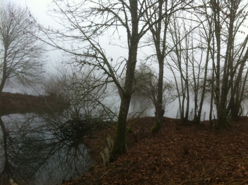
The Delta Ponds on a foggy winter morning.
The herons caused me to stop. Standing there, face-to-face with the Delta Ponds, it quickly occurred to me that they weren’t natural ponds. I looked around and took in my surroundings, in the middle of an isolated and strangely preserved natural area between a river and a highway. Suddenly, several clues came together, and the combination of the geographical location and the surrounding place names provided a pretty accurate assessment of the area’s history. The Delta Ponds were right alongside the Delta Highway, which essentially acts as a driveway up to the current riverfront mining operation of Delta Sand and Gravel. I only had recently learned about the mine at the northern end of the highway, but my visits up there had provided an instant reference for the use and nature of the immediate area.
Delta, I thought to myself. These ponds must be restored gravel mines which have been reconnected to the river, which means that this spot is possibly a former channel or side-channel of the Willamette River. The name of the road which loops around the Delta Ponds, Goodpasture Island Road, suggests that this patch of land was once cut off by a waterway, and used for grazing prior to it being mined for gravel. Not only was it a gravel mine, but the highway leading up to the current mine was most likely paved with the gravel that was mined right here.
A few minutes of iPhone research confirmed the bulk of my theory as well as filled in the missing gaps. The area was indeed once a side-channel of the Willamette, which was an important component of the river ecosystem, but the side-channel dried up around the turn of the century due to man-made alterations of the land. The land was then marshy pasture that was mined for gravel in the ‘50s and ‘60s, and then sold to the City after the gravel was exhausted, where the pits sat untouched for nearly forty years as the land around them was further altered and developed.
During that time, it suffered the same fate that many old gravel pits do: the pits flooded, and while they became a natural wildlife habitat over time, the pits also became over-run by invasive species such as blackberry and Scotch broom. Finally, with help from the Army Corps of Engineers, the city embarked on a $9 million-dollar restoration project, taking the greater part of a decade to complete, which removed the invasives, altered the steep slope of the gravel pits, and eventually reconnected the ponds to the river. Today, the restored side-channel habitat is the home to nearly 150 bird species, including herons, falcons, owls, and several varieties of hawk. A beautiful, concentrated wildlife preserve birthed out of an old gravel mine, strangely nestled between a river, a highway, and scores of condominiums and housing developments. It was a wonderful and unexpected discovery; despite its urban backdrop it felt hidden and sacred. And while I immediately appreciated the areas for the rare and beautiful habitat that it was, I also realized not only did this area stand out as an exception of sorts, but that it most likely stays off people’s radar as much as the issue of gravel mining itself does.
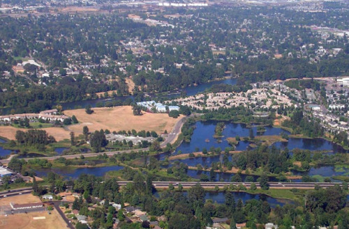
The restored Delta Ponds with the Willamette River in the background.
Unlike the more well-known resource extraction practices such as clear-cutting, which leaves a visual scar that’s simply impossible to ignore as one drives or walks by, gravel mining is naturally much more obscured from public view, given that it often occurs in a pit. For the most part, the impacts of gravel mining are rarely seen from ground level, and citizens are often ignorant about mining operations that are practically occurring in their neighborhoods. As a result, while clear-cutting practices are the subject of much public outcry and heated debate, few words are said of the deliberate ecological destruction and devastation of our riverbanks that has been occurring since the early 1900’s. Most people generally have no idea that the vast majority of land along the confluence of the McKenzie and Willamette rivers north of town is owned by gravel mining corporations, or that much of the land which stretches from the confluence of the Middle and Coast Forks of the Willamette eastward towards and past Mt. Pisgah had been mined continuously for the past eighty years. Pristine parks and recreation areas border former gravel mines, and those using the parks are usually completely unaware that the remnants of gravel mining are out in plain sight only yards away.
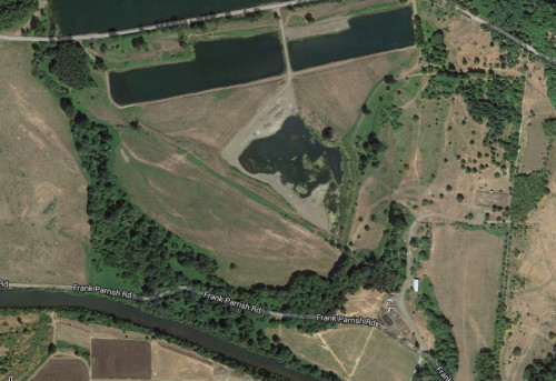
Flooded gravel pits between the Middle Fork and the Coast Fork of the Willamette River. The grassy field at the very bottom is the site of the annual Faerieworlds festival.
Standing out over the Delta Ponds, it occurred to me that there’s a blessing in the fact that at least certain gravel pits can be restored in a generation, as opposed to clear-cuts that easily stand out fifty years later. The Delta Ponds, however, is a rare exception in that it is restored, as flooded gravel pits dot the landscape up and down the riverbank for miles and most are either listless or overgrown with blackberries. When I first gained awareness about the amount of gravel mining in the area, I visited several sites, on foot, on bike, and driving by. But aside from the occasional large crane sticking up out of the sky, it was hard to gain a real sense of the mines themselves. It wasn’t until I started studying Google aerial satellite images that I truly started to understand the impacts, cycles, and sheer ugliness of open-pit mining. Taking in the view from above is what really drilled it home.
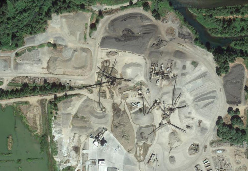
Pit mine on the south bank of the McKenzie River
The cement drills outside my window last summer also recently drilled it home. From May through September, a good number of the roads downtown were re-paved in a massive project paid for by a voter-approved bond. The condition of the roads and the actual need for repaving was somewhat debatable in my opinion, but the repairs created much-needed jobs, and provided a significant economic boon for the local sand and gravel companies. As I learned has been the case since the 1920s, the roads were paved exclusively by local companies and mined from either the Willamette or McKenzie, a fact that was stressed by company heads as a positive aspect. And while tapping into the “keep it local” energy was a brilliant move on the part of the gravel companies, it was bothersome to noticed such a disconnect on the part of the community. Well-meaning citizens celebrate keeping it local, but they fail to understand exactly how local and how significant the impact is, and they truly fail to recognize that not all of those local impacts are positive. While the Delta Ponds stands as a testament to something sacred that can be created out of the profane, it’s a very small gain when compared to the overall amount of land that has been or is being ripped apart for gravel.
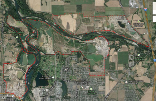
Confluence of the Willamette and McKenzie rivers. Gravel mining operations are outlined in red.
Last June, the “finite” aspect of what are recognized as “finite natural resources” became a subject that caught the public’s attention. Delta Sand and Gravel’s most recent application to expand their mining operation at the end of the highway was rejected last spring by County officials, and in the ensuing media coverage Delta representatives stated that without the expansion, the company is set to run out of gravel in less than 15 years. For nearly a century, the aggregate that makes up the entirety of roads, sidewalks, jogging paths, and driveways has been “proudly” mined in Lane County by Delta and other companies, and Delta is forecasting a potential end to that tradition, at least in terms of their operation. The County is currently (and rightly) maintaining the need to protect zoned farmland, but Delta’s statements signal a future and possibly significant showdown over land-use on the riverbank. Even if current land-use laws were ignored, the reality is that the supply of gravel is still finite. One day the mining companies will be out of land. The land-use battles of present and future will only determine how much arable farmland is still available when that does happen.
In the meantime, however, Delta Ponds exists as an example of how such destruction can be successfully restored, and I am grateful for its existence and for my stumbling upon this place and the story behind it. For me, the ponds stand as a reminder of how environmental destruction can be taking place right in our midst and yet still remain hidden from view. Sometimes it takes an adjustment, a different perspective, to be able to see a situation clearly for what it is. In this case, I found great value in the view from above.
* * *
The views and opinions expressed by our diverse panel of columnists and guest writers represent the many diverging perspectives held within the global Pagan, Heathen and polytheist communities, but do not necessarily reflect the views of The Wild Hunt Inc. or its management.
The Wild Hunt is not responsible for links to external content.
To join a conversation on this post:
Visit our The Wild Hunt subreddit! Point your favorite browser to https://www.reddit.com/r/The_Wild_Hunt_News/, then click “JOIN”. Make sure to click the bell, too, to be notified of new articles posted to our subreddit.
Whilst I do not think that mankind should be raping the land in the way that it does, I think the least they can do is make reparations once they have finished.
In the UK, we have the Broads – a series of lakes and connecting rivers in Norfolk and Suffolk. They have a level of protection similar to our National Parks and are seen as vital wildlife havens (and they are). However, they are also man made.
Whereas the Delta Ponds are the result of recent gravel extraction, the Broads are the result of medieval peat extraction. Originally, they would have been woodland (like most of the rest of the British Isles), but the woods were largely cleared and converted to farmland.
Ironically, by digging up the peat, what we have now is far richer an environment than if it had been left for the farmers.
Fascinating article, Jason. I learned a lot from it. This stood out to me:
“The land was then marshy pasture that was mined for gravel in the ‘50s and ‘60s, and then sold to the City after the gravel was exhausted, where the pits sat untouched for nearly forty years as the land around them was further altered and developed.
. . . [T]he pits also became over-run by invasive species such as blackberry and Scotch broom. Finally, with help from the Army Corps of Engineers, the city embarked on a $9 million-dollar restoration project, taking the greater part of a decade to complete, which removed the invasives, altered the steep slope of the gravel pits, and eventually reconnected the ponds to the river.”
So a private company extracted the resources and sold the then-ruined land back to the City (aka, got tax dollars and got rid of the results of the extraction). Then, later, $9 million of tax dollars was used to restore the land. That’s insane. When utilities build electric plants, they have to collect money that will be used to restore the site once the plant is gone. All businesses should have to do the same.
The story of what’s happened to this particular piece of land does have a happy ending, but it demonstrates the need to stop letting corporations make money by externalizing costs to everyone else.
Just FYI, the article was written by Alley Valkyrie, I’ve corrected the byline. My mistake!
Agreed, and the Delta Ponds is far from the most egregious local example. A few years ago, after fifty years worth of destroying the riverbanks near Mt. Pisgah, the mining company (Wildish) sold the land to The Nature Conservancy for $24 million, with the money mostly donated by the Bonneville Power Administration. Now the Nature Conservancy wants both the local and federal government to help them restore the confluence. Why was Wildish paid such a huge amount for land that they already made a fortune off of? Shouldn’t they have paid to restore the land, as opposed to selling it to a questionable non-profit that now wants to engage in a “public-private partnership” with local and federal authorities in order to restore it? And why did a federal agency donate public money to put the land in private hands? Why can’t those who destroy land just fix it themselves?
Because those with money and power value the economy above the ecosystem.
I will set the avaricious a challenge – Put aside both money and oxygen and see which they can do without the longest.
Alley, first, thanks for writing this post. When I first read it, I wondered whether it was you or Jason who wrote it.
Second, BPA is an arm of the Federal Government. So if It donated the money to buy the land near Mt. Pisgah, that money either came from federal tax dollars or from money that BPA made (i.e., from money that the federal gov’t made) selling power or transmission (generally at low cost) to people in the West.
My point, again, is that we need to stop allowing corporations to get rich by externalizing their costs to the rest of us while they privatize the profits. We need regulations that require those who profit from our shared natural resources (gravel, coal, forests) to also restore the lands they rape. If they can’t do so profitably, maybe they shouldn’t be extracting resources at all.
Wonderful reconstruction of what was- love how you picked up on clues from street names. This is great writing.
Great story…I would like to add, here in SE TX, nature takes back the gravel pits without the taxpayer dollars….the road builders down here will recycle the concrete from the road they are destroying. Once we have a crunch between farms/food and road gravel, things may change, tho
This is a great article! I always enjoy your writing, Alley. I like how rooted in place your articles are and the ways in which you explore your local surroundings in a way it doesn’t occur to most of us.
Absolutely beautiful local history, Alley. Thank you for showing how much we can learn by looking closely at where we already are, and digging deep. (And of course I share the outrage of other commenters about “privatized profits, public costs.”)
Great job of reconstructing history and what you see with your own eyes in nature. Here in Pennsylvania the whole northern part of the state was mined for anthracite coal, so the hills you think are natural are actually piles of inferior coal, which they are now once again mining. The old shaft mines still leak acidic and sulfurous yellow water into our streams, and there is no stopping it. Here in the US at least nowadays mines and garbage dumps Have to pay for land restoration, though the cost is still passed on to us for the product of course. And then there is the whole new practice of fracking for gas, which has kept the price of propane stable and low, but who knows the environmental impact in the future. Good story so thank you. http://blausternschlonge.wordpress.com/