TWH – In late 2022, Ancient Mesoamerica published a research paper on a discovery that challenges the understanding of the Maya Pre-Classic period (1000 B.C.E. to 150 C.E.). The new discovery was detected using technology known as LiDAR (“light detection and ranging” or “laser imaging, detection, and ranging”), which indicates higher population densities than previously thought to have existed.
This new information implies that Mayan society may have been more complex and organized than previously thought. Archaeologists found 417 ancient cities, towns, and villages in the Mirador-Calakmul Karst (MCK) Basin of northern Guatemala and southern Mexico.
Modern Pagans may find the ceremonial structures in these 417 settlements interesting since those structures are the material remains of the Mayan religion.
A series of elevated causeways connected these 417 settlements, which shared common architectural styles, indicating a shared culture. To build these settlements, the Maya would have needed a large labor force. That would likely have required a complex socio-political organization.
LiDAR is “a remote sensing method that uses light in the form of a pulsed laser to measure ranges (variable distances) to the Earth. These light pulses—combined with other data recorded by the airborne system — generate precise, three-dimensional information about the shape of the Earth and its surface characteristics.”
Cheaper and quicker than manual excavation, LiDAR does not disturb the material environment. It has been especially useful in exploring densely forested land areas.
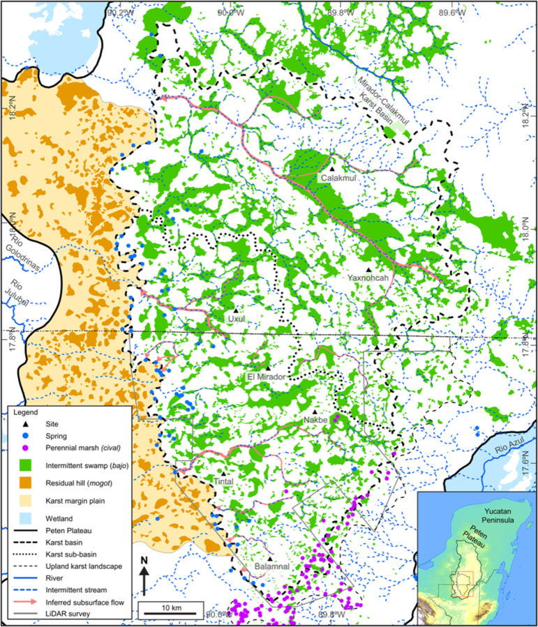
Drainage map of the MCKB in the southern Peten Plateau, which is a fluviokarst landscape dominated by seasonally inundated bajos and intermittent streams. Numerous civales occur in the southeast MCKB, and springs exist at the base of low hills punctuated by dry karst valleys at the edge of the karst basin. Over time, the west karst margin border and plain have eroded, leaving residual hills, or mogotes. Modified after Ensley et al. (2021).
Upland hills form the borders of this basin with low-lying seasonal swamps, or “bajos,” dominating the area. Causeways would have connected and made it possible to travel to the various sites undeterred by the bajos.
The Settlements
The research article authors, Richard D. Hansen, Carlos Morales-Aguilar, Josephine Thompson, Ross Ensley, Enrique Hernández, Thomas Schreiner, Edgar SuyucLey, and Gustavo Martínez, assigned settlements to one of six tiers. Criteria for tier placement included settlement area, ceremonial structures, and structural volume per square kilometer.
The authors hypothesized that settlement size, ceremonial structures, and causeway “connectedness” reflected a hierarchal organization of society. The only Tier 1 settlement, El Mirador, stood out. It had the largest surface area, 132 square kilometers (51 square miles). It had the largest number of ceremonial structures, causeways, reservoirs, and carved monuments, totaling 132.
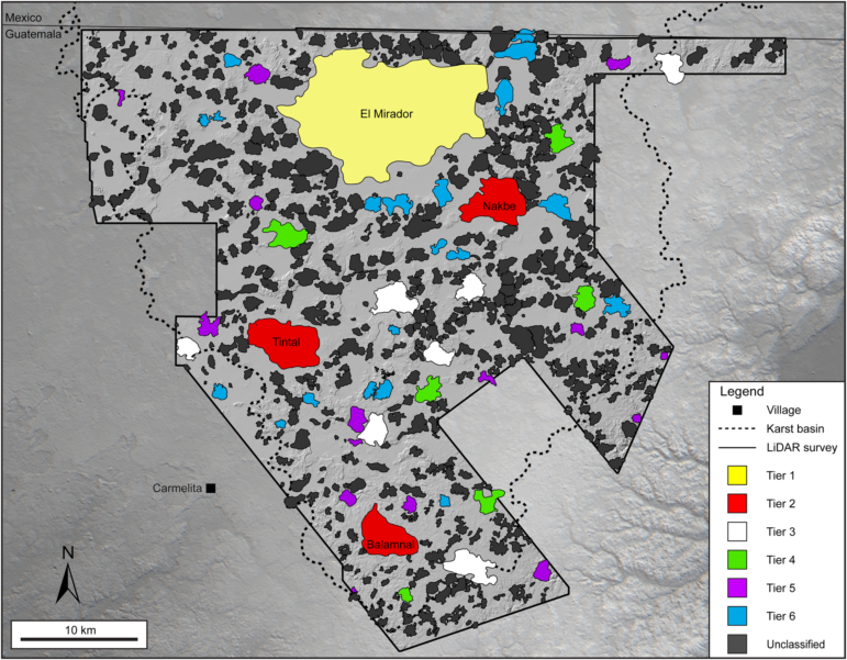
Site center map of the southern MCKB. Polygons represent cohesive site centers identified through GIS analyses of LiDAR, near-infrared data, and ground surveys throughout the southern half of the MCKB. Individual centers may consist of several settlements as suburbs or peripheral sites that are closely affiliated. Polygon colors are proposed tier levels. Digital elevation: ALOS World 3D (AW3D30), Japan Aerospace Exploration Agency, and FARES LiDAR.
The authors also hypothesized that El Mirador functioned as the “capital” of the region. A Tier 2 settlement, Nakbe, had only 36 ceremonial and communal structures. The other two Tier 2 settlements had fewer. Nakbe had a total surface area of 15 square kilometers (5.8 square miles).
Tier 2 settlements had a surface area ranging from 13 to 19 square kilometers (5.0 to 7.3 square miles). Tier 2 sites had “fewer large reservoirs and carved monuments.” Their tallest ceremonial and public structures had heights of 50 meters (164 meters).
Tier 3 settlements had surface areas ranging from 2.7 to 8 square kilometers (1 to 3.1 square miles). Tier 3 sites had five structures with heights ranging from 8 to 20 meters (26.2 to 65.6 feet).
Tier 4 settlements had surface areas ranging from 1.01 to 4 square kilometers (0.39 to 1.5 square miles). Tier 5 settlements had surface areas ranging from 1.2 to 3.04 square kilometers (0.39 to 1.2 square miles). Tier 4 and 5 settlements differ in the types of ceremonial and public structures within each. Tier 4 settlements have more “triadic structures” than Tier 5 settlements.
Tier 6 settlements have surface areas ranging from 0.16 to 1.5 square kilometers (0.06 to 0.6 square miles). All Tier 6 sites, but one, have structures exceeding 12 to 22 meters (39.4 to 72.2) in height.
Among Mayan homes, archaeologists found “marked inequality of size and sophistication of architecture.” This inequality would be consistent with a hierarchically organized social system. They also noted a lack of imported goods.
Ceremonial and public structures
The researchers estimated the labor necessary to build these ceremonial structures. Building the pyramid complex at Danta would require between 6 and 10 million person-days of labor. This organization of labor suggests a complex society in the pre-Classic period.

Site map of the southern MCKB. The concentration of sites and causeways in the MCKB demonstrates the likely economic and political cohesion of the area. The background near-infrared image indicates the vegetation types with lowland, or bajo, vegetation in blue-green and upland vegetation in red. Causeways do not extend beyond the natural borders of the basin, suggesting an enclosed centralization associated with settlement nucleation in the Middle and Late Preclassic periods. Sentinel-2 multispectral data.
Ceremonial and public structures include ballcourts, “E-Groups,” “triadic complexes,” inter-site/intra-site causeways, large reservoirs, and monuments (carved and non-carved).
Archaeologists found at least 30 ballcourts in the MCK Basin. In the MCK Basin, ballcourts tend to have a north-south axis. They tend to be 10 to 20 meters long (32.8 to 65.6 feet). El Mirador has four small ballcourts and three larger ones in the Great Central Acropolis.
On the Great Central Acropolis, archaeologists found a “royal throne, specialized ceremonial sunken plazas, elaborate cosmological iconography, reservoirs, hydraulic systems, and massive platforms.” These features would be consistent with El Mirador as the regional “capital” of the MCK Basin.
An E-Group consists of an elongated platform with a north-south axis. On its west side, sits a dominant pyramid. E-Groups appear early and consistently in the Mayan lowlands. Archaeologists found E-Groups in all six tiers.
In the MCK Basin, archaeologists found 42 E-group structures. In El Mirador, the Leon E-Group has a height of 33 meters (108.3 feet). Another site, Wanka, however, has the greatest length, 210 meters (689 feet).
Triadic complexes consist of a dominant structure, flanked by “two, inward-facing smaller mounds.” They are the most common ceremonial or public structures in the MCK Basin.
Causeways permeate the MCK Basin. Intra-site causeways link the various parts within a settlement. Others, inter-site causeways link one settlement with another. LiDAR mapping found 133.2 kilometers (437 feet) of inter-site causeways. It found 38.23 kilometers (125.4 feet) of intra-site causeways. Five major inter-site causeways connect to El Mirado. Besides those five inter-site causeways, 12 intra-site causeways connect to El Mirador. The causeway pattern of El Mirador has the form of a central hub. That form is consistent with El Mirador as capital.
Intra-site causeways have a width of 9 to 40 meters (29.5 to 131.2 feet). The inter-site causeways have a width of 28 to 40 meters (91.9 feet to 131.2 feet). The inter-site Paixban causeway had a height of 2 to 4 meters (6.6 to 13.1 feet).
The researchers noted that this careful review of the Mayan lands “is long overdue” and that the articles in the special section of the journal “present data and address specific issues from throughout the Lowlands, revealing the complex nature of the cultural and sociopolitical developments in the Maya region during the Preclassic period.”
The Wild Hunt is not responsible for links to external content.
To join a conversation on this post:
Visit our The Wild Hunt subreddit! Point your favorite browser to https://www.reddit.com/r/The_Wild_Hunt_News/, then click “JOIN”. Make sure to click the bell, too, to be notified of new articles posted to our subreddit.