The Wild Hunt has published a number of updates on the proposed Stonehenge tunnel in the last couple of years. Where do things stand with England’s most famous ancient monument in March 2022?
WILTSHIRE, England – Planning permission for the tunnel on environmental grounds was overturned last summer, in July 2021. Recently, in February of this year, National Highways has spent £5.25million on publishing new documentation relating to its plans for Stonehenge, including environmental documentation.

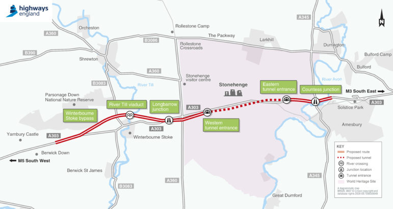
Image credit: Highways England
Construction News stated that:
“The £1.7bn proposal includes plans for a 13km two-lane dual carriageway on the A303 between Amesbury and Berwick Down, part of which will be tunnelled over for 3.3km. The plans also include a northern bypass at Winterbourne Stoke with a viaduct over the River Till valley, and two new junctions between the A303, and the A345 and A360.”
Comments are invited for the planning application review and, Transport Secretary Grant Shapps says, must be in by April 4th.
He has also invited National Highways to expand on its claims regarding emissions: the road’s operator says that the rise in greenhouse gas emissions under the proposal “would have no material impact on the ability of the government to meet its carbon reduction targets.”
Most of the £5.25 million has been spent on technical consultancy (National Highways have published a breakdown of the figures of its most recent spend) but it has been clear that it is still excluding alternatives to the core proposal, for example, extending the length of the tunnel.
The New Civil Engineer website says that it is “unclear” as to what changes have been made to the plan. Environmental groups have criticised the amount of money being spent on a revision to the Stonehenge plans and on those relating to the Lower Thames Crossing, another controversial road initiative in the south of England.
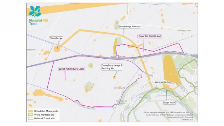
However, there have also been developments elsewhere in relation to the Stonehenge site. The National Trust revealed in March that it has acquired two areas of land near the monument and intends to restore them to chalk grassland. One of these includes part of the Avenue, the one-and-a-half-mile route which runs up from the River Avon to the main monument. This could give visitors an enhanced sense of what it must have been like for ancient pilgrims to approach Stonehenge.

Image credit – National Trust
The second land acquisition contains the Neolithic feasting pit of Coneybury, a mile to the southeast of the main monument and close to an older, smaller henge. Both sites, which have been damaged by ploughing, have thus been removed from Historic England’s at-risk register.
National Trust archaeologist Nick Snashall told The Guardian last week, “Arable farming can be hugely damaging to archaeology, year after year erasing more and more of the story of the people who built and used the monuments in this landscape.”
Snashall continued, “It’s fantastic news that we’ve been able to take the single most important step in protecting these sites in decades, by bringing this additional land into our care. By returning them to species-rich chalk grassland we’re both making a home for nature, and ensuring the stories this landscape holds will be here for everyone to discover and enjoy long into the future.”

The Avenue at Stonehenge looking towards Old and New King Barrows (2014) – Image credit: Ashley Columbus – CC BY-SA 3.0
Over 80% of Britain’s chalk grassland has been lost since WWII. In the last 2 decades, the National Trust has been undertaking one of the largest grassland reversion programmes in Europe. The reversion sites contain a wealth of flora and fauna, such as brown hares, skylarks and Adonis blue butterflies, a number of rare moths and beetles, and plants such as cowslip, sainfoin, pasque flower and prickly poppy. Regular early morning visitors to the henge often see hares among the stones.
Regional director at the National Trust Rebecca Burton, also quoted in The Guardian, said, “We have been working for years to revert more of the Stonehenge world heritage site to chalk grassland which, as well as protecting the archaeology, will allow nature to thrive. It will mean people will be able to experience a landscape that would have been more familiar to the builders of Stonehenge.”
We asked U.K. Pagans for their views and had this response, from a local resident who prefers to remain anonymous:
“I regularly walk the National Trust open access land around Stonehenge and think any extension of that would be a good idea. I know one of the pieces of land purchased, it is a location which would allow seeing the midsummer sunset over Stonehenge from the landscape in a place which is currently not publicly accessible.
“Similarly, it is also a place to watch moonsets from at differing times of the year. I like the fact that with open access you are not restricted to footpaths and can roam across the fields, not usual farming policy, it does enable a connection to the landscape for those who want to. The bigger the space to do this, the better really.
“I do notice though, the usual claim that one day the Avenue will able to be walked along the full ceremonial route. The part near the Avon has a couple of houses and local roads running across it, meaning that will not happen indicating a disconnect by management from the reality on the ground.
“But that does not matter when you are out walking on a misty morning watching the sun rising or the moon setting. The important part is the land being free to access at any time of day and night and this will enable more of it.”
Duncan Wilson, Chief Executive of Historic England said, “The Stonehenge landscape contains an extraordinary and diverse range of archaeological sites and monuments which are of both national and international importance. Some of these sites close to Stonehenge were vulnerable to continued arable cultivation including Bronze Age round barrows and part of the Stonehenge Avenue – the ceremonial monument linking Stonehenge to the River Avon.”
Wilson continued, “We are delighted that the National Trust has been able to secure the conservation ownership and control of this land leading to the removal of six key monuments from our Heritage at Risk Register and the protection of other important archaeological remains. This will also help facilitate wider access to the landscape, a further step towards one day in the future the exciting prospect for people to once again walk the ceremonial route along the Avenue.”
The Wild Hunt is not responsible for links to external content.
To join a conversation on this post: Visit The Wild Hunt subreddit! Point your favorite browser to https://www.reddit.com/r/The_Wild_Hunt_News/, then click “JOIN”. Make sure to click the bell, too, to be notified of new comments in our subreddit.