TWH – The Scotsman and Live Science both reported that archaeologists found a previously unknown Neolithic structure on the Isle of Arran, Scotland. They found a cursus, one of the more mysterious structures of the Neolithic (4000 to 2500 B.C.E.).
A cursus consists of two parallel ditches or earthen banks. Timber posts sometimes outlined these structures, and occasionally people burned those timber posts. The posts may have served in processions and were part of ritual activity possibly involving the veneration of ancestors.
This newly discovered cursus dates from roughly the same period as Stonehenge. (The word “cursus” takes the same form in the plural as it does in the singular.) Today, most archaeologists believe that a cursus marks the route of a procession.

Site of Isle of Arran [credit: 汲平, Public domain]
In 2017, LiDAR (Light Detection and Ranging), a form of aerial archaeology, identified two almost parallel lines on the Isle of Arran. Field visits in 2017 and 2019 found two parallel mounds on the ground where LiDAR indicated. Those mounds have gaps in them.
At present, no one knows the reason for the gaps in the two lines of mounds. Those mounds extend for 1.1 km (0.68 miles), with the distance between the two mounds ranges from 30 (98 ft) to 40 meters (131 ft). The mounds themselves measure roughly 3.3 m (10.8 ft) thick and 0.3 m (1 ft) high. The research team does not think the structure had a roof.
Cursus appear in many Neolithic ceremonial complexes in Insular Europe. In the area now known as Scotland, archaeologists have found about 70 cursus. Almost all known cursus are on its east coast. The Isle of Arran lies on its southwest coast. According to The Scotsman, archaeologists have found only one other cursus, the Kilmartin Glen cursus, on its west coast.
Dave Cowley, the lead archaeologist on this project, specializes in aerial archaeology and LiDAR. Aerial archaeology involves using views from planes, helicopters, and increasingly drones.
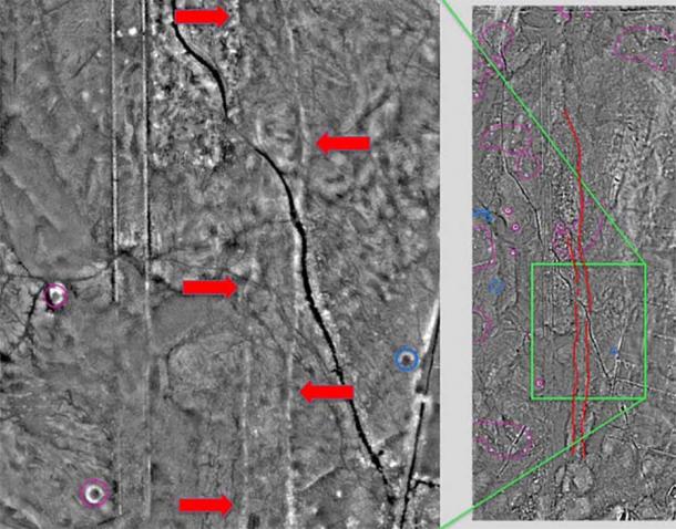
The site of the cursus monument was discovered after these two parallel lines, marked here by red arrows [via © Historic Environment Scotland]
LiDAR and aerial archaeology have identified possible archaeological sites. It is much cheaper than an investigative excavation. In terms of significance, archaeologists have compared LiDAR to radiocarbon and tree ring dating.
The Isle of Arran
Note: The Isle of Arran lies off the west coast of Scotland. The Aran Islands lie off the west coast of Ireland.

Isle of Arran – Image credit: Christopher Steinle, CC BY 3.0
People have lived on the Isle of Arran since the early Neolithic. According to the 1911 Encyclopedia Britannica, inhabitants on the island in 1911 were either bilingual or monolingual Scots Gaelic speakers. Nineteenth-Century “clearances” drove many farmers off their lands. They ended up migrating to Canada. Like the Potato Famine, those clearances lowered the status of Scots Gaelic in Arran. That loss of status began its decline. With that decline, much of the local culture and knowledge of the land embedded in the language began to disappear. Today, only 1.5% of the population of the Isle speaks Scots Gaelic.
According to David McOmish in British Archaeology antiquarians had given these structures the label of “cursus.” They thought that cursuses were racecourses where the Iron Age Celts held chariot races.
British Archaeology reports variations among cursus
By definition, a procession goes somewhere. Cursus have open-ended, rounded, or square cut termini. These different ends could reflect stylistic or cultural differences. Or they could also reflect differences in what happened as the procession ended. A type of ritual procession could have occurred. Some cursus extended over great distances; others were short. The label, “cursus,” refers to structures with many different forms and, maybe, uses.
The terminus of a cursus may have been its most important feature. The terminus of the Springfield Cursus enclosed a timber circle. The Dorset Cursus had a more massive scale than either of its banks. The Woldgate Cursus and the Greater Stonehenge Cursus show evidence of repeated rebuilding of their termini. People from the Bronze Age built two flint cairns over the terminus of the Woldgate cursus.
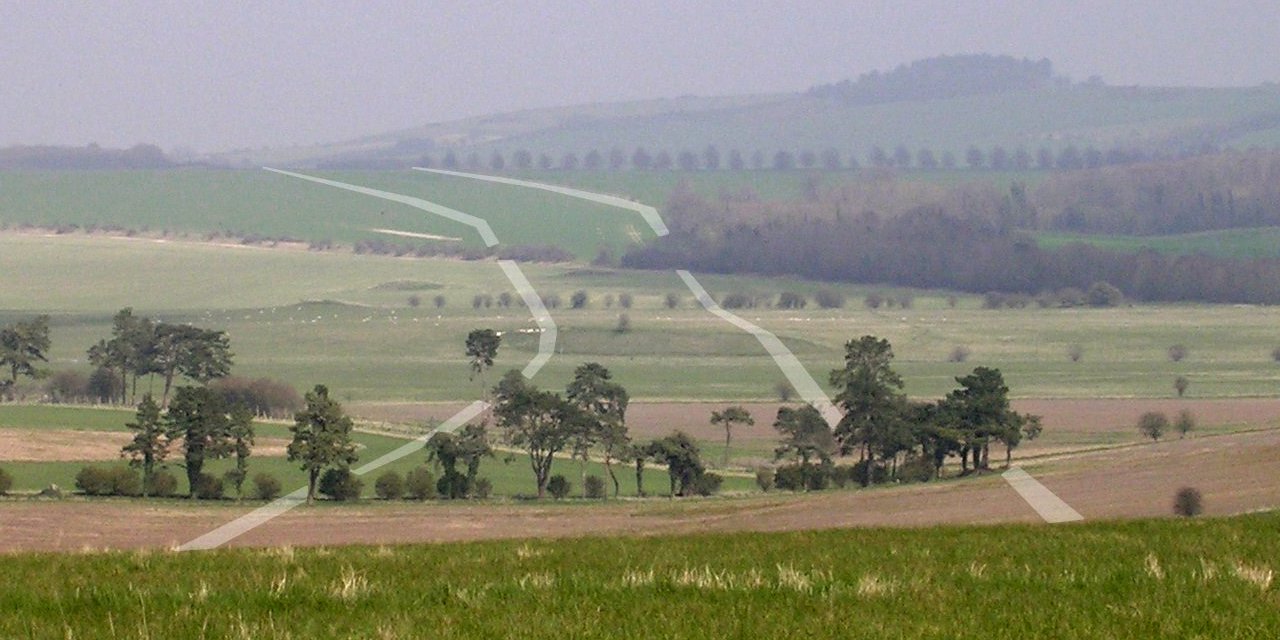
View northeast from Gussage Hill towards Bottlebush Down. The approximate course of the banks of the neolithic Dorset Cursus is superimposed on the photograph in white. Image credit: Jim Champion - CC BY-SA 3.0, https://commons.wikimedia.org/w/index.php?curid=1318603
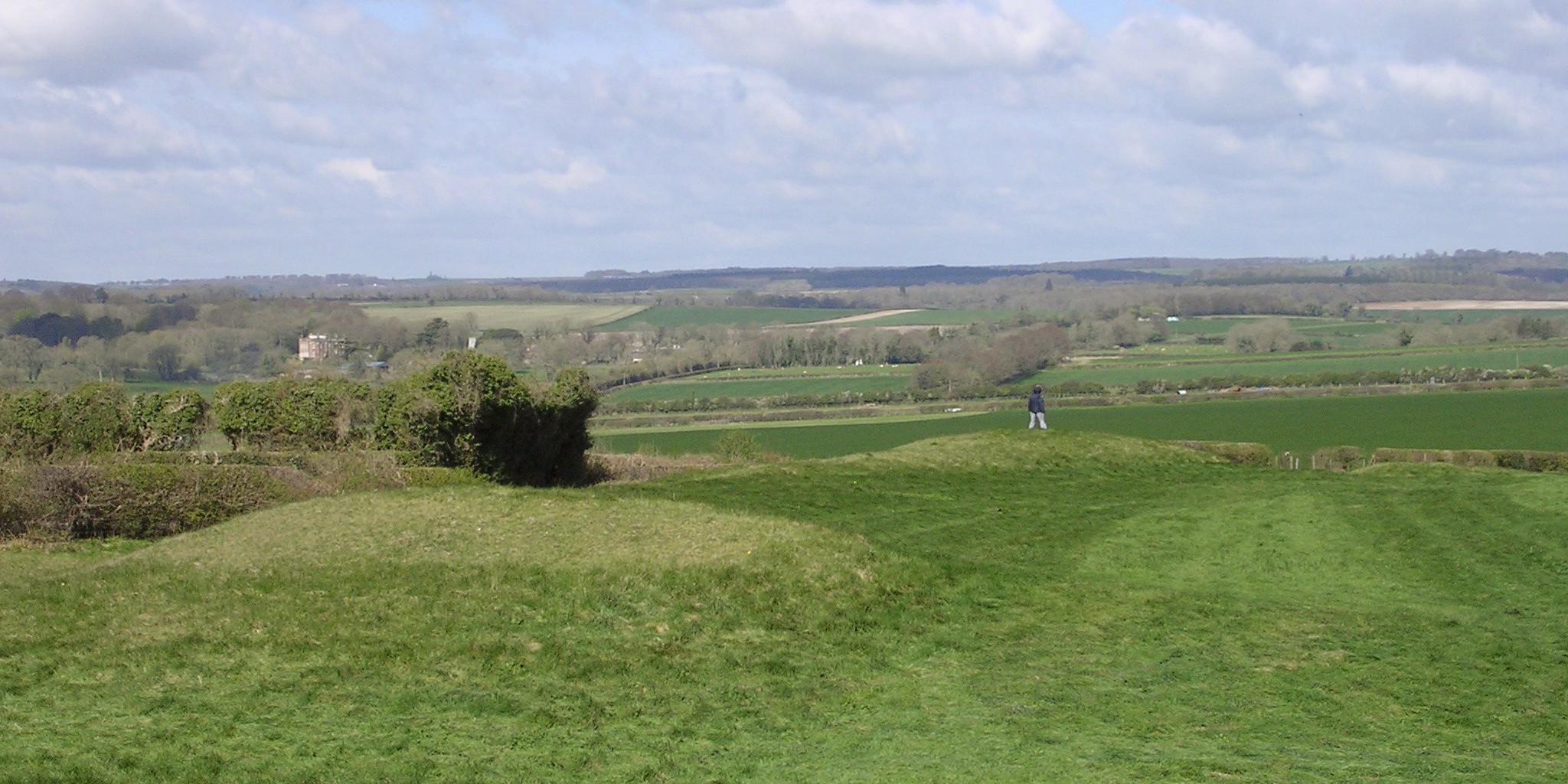
Looking northwest at the earthworks of the Dorset Cursus' southwestern terminal from the nearby long barrow. The enlarged bank ends can be clearly seen, and the end of the cursus is squared off with a terminal bank about 100m in length. The course of the Cursus heads off to the right of the picture, towards the long barrow on Gussage Hill. Image credit: Jim Champion - Own work, CC BY-SA 3.0, https://commons.wikimedia.org/w/index.php?curid=1321468
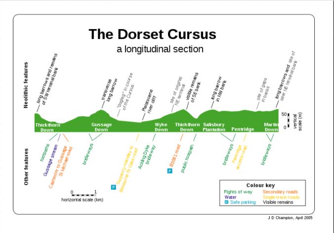
A longitudinal section of the Dorset Cursus, listing the neolithic and modern day features along its course on Cranborne Chase, Dorset, U.K. Image credit: Jim Champion - CC BY 2.5, https://commons.wikimedia.org/w/index.php?curid=1321324
The largest cursus, the Dorset Cursus, has a length of 9.7 km (6 miles). Several others also extend over a great length, ranging from 2 km (1.2 miles) to 4 km (2.5 miles). Some, however, have a length less than 250 meters (820.2 ft.).
Once built, a cursus became part of the landscape. Later, people from other cultures aligned their structures with these earlier features. Neolithic people partially buried the Lesser Cursus at Stonehenge soon after its construction. Nevertheless, people later aligned their burial mounds along the flank of that cursus. Sometimes, they built burial mounds at either end of that cursus.
People from the Bronze Age, about a thousand years later, aligned their field ditches with the central mound of the Stanwell Cursus. A field system of the Romans used the Drayton cursus as an earthwork.
An animist might feel that the cursus had become part of the living landscape.
Several cursus show signs of alignment. The 700-meter (2,296.6 ft) Springfield Cursus is aligned with a smaller structure 300 meters (984.3 ft) distant. The path of the Dorset cursus extends between the northeast to the southwest. If the procession moved to the southwest, it would be consistent with a midwinter sunset ritual.
People built cursus in liminal spaces. Neolithic people built most cursus in low-lying areas, alongside valleys and streams. They often link two waterways. Sometimes, people built them where the geology noticeably changes.
In heavily forested areas, Neolithic people built with readily available wood or earth. Wood failed to survive. Earthworks were subject to erosion. More rarely, they built into rock and stone, such as dolmens and Stonehenge.
Compared with people from the Neolithic, Iron Age Celts left voluminous records. No one knows what language the people of the Neolithic spoke. No one has any idea what gods they invoked or what rituals they performed. Nor do we know the boundaries between the different cultural groups of the Neolithic.
All that moderns know about them comes from their material remains that have been found. Based on those remains, modern scientists have made inferences about the people and their culture. Almost all we know about that period is mysterious and tentative. Of all the surviving material remains of the Neolithic, the cursus may be the most mysterious.
The Wild Hunt is not responsible for links to external content.
To join a conversation on this post:
Visit our The Wild Hunt subreddit! Point your favorite browser to https://www.reddit.com/r/The_Wild_Hunt_News/, then click “JOIN”. Make sure to click the bell, too, to be notified of new articles posted to our subreddit.