TWH – The impacts of climate change this year have increased droughts, extreme storms and flooding, and extreme wildfires around the globe. However, this year’s summer droughts have also revealed something else. As rivers and reservoirs dry up, the objects buried beneath their waters have started to emerge.
The Rhine
A report for the European Union, the Kiel Working Paper No 2155 described the gauging station at Kaub, Germany as “decisive.” The Rhine carries all freight from the North Sea to Germany’s industrial southwest. It passes Kaub. The German Federal Institute for Hydrology has defined a water level lower than 78 centimeters (30.7 inches) as the “low water level threshold” for navigation along the Rhine. When the water level falls below that threshold, barges have to reduce cargo. What one barge had previously carried, now requires four barges to transport.
The BBC reported on water levels in the Rhine. Waters have dropped so low that some ferries had to stop operations. In some areas, the Rhine has a depth of only 1.5 meters or less than five feet.
Around the town of Kaub in Germany, only some ferries still run. They need at least 1.2 meters (3.9 feet) of water to operate. If the Rhine drops another 30 centimeters (11.8 inches), the bottom of the ferries would scrape the river bottom. Traditionally, October is the driest month along the Rhine.
Still, the Rhine had not yet dropped below its lowest recorded measure. In 2018, the Rhine at Kaub had fallen to 25 cm (9.8 inches) at the gauging station. As of mid-August, it measured 42 cm (16.5 inches) at that same station. The gauging station measures water depth at that point, not at the deepest part of the river.
Upriver at Bingen in Germany, the sun has bleached dried large parts of the riverbed. Only a few commercial vehicles travel the Rhine in this area.
If the water levels fall below a certain point, Dutch, French, German, and Swiss authorities may have to close parts of the Rhine to shipping.
Hunger Stones along the Elbe
As reported by the BBC, the receding river waters have revealed “hunger stones.” People had marked these stones with the years of prior droughts. Crops covering the stones have been a marker for hardship. Their emergence in the past meant crop failures due to drought. These stones serve as a “warning to future generations that when the stones are above water, hardship lies ahead.”
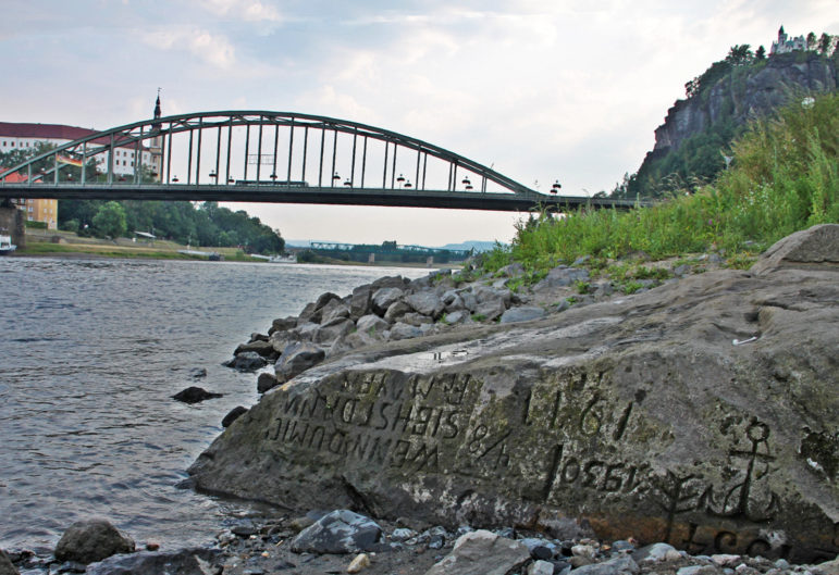
Hunger rock marking low levels of the Elbe River in Děčín – Image credit: Norbert Kaiser – CC BY-SA 3.0
The stones along the banks of the receding Elbe River have become visible for anyone to see. The Elbe river flows from Czechia through central Germany and out into the North Sea. One stone from the 1400s became visible in 1616. In that year, someone had inscribed it with the plaintive sentence, “If you see me, cry.”
The Spanish Stonehenge
The Smithsonian Magazine reported on one aspect of the drought in Spain. The “Spanish Stonehenge,” the Dolmen of Guadaperal, has emerged from an evaporating reservoir. Located in central Spain, this megalithic monument dates to 5000 B.C.E.
In 1963, it was deliberately flooded to create a reservoir. It has only emerged from the reservoir a few times. This drought, however, has exposed a great deal more of the monument, allowing archaeologists to readily study the monument in detail.
ABC News aired a segment on the Franco dictatorship that built that dam in 1963, as part of a rural development project. The result is what caused the flooding that covered the megalithic monument. The reservoir is now at 28% of capacity.
Nero’s bridge
The receding water levels of the Tiber in Italy have revealed much of a bridge, as reported by NBC news. While some parts of the bridge had become visible before when water levels dropped, this time even more of the bridge has become visible.
Historians think that Nero (Emperor 54 to 68 C.E.) may have built this bridge, the Pons Neronianus, around 50 C.E.
China
NBC News has reported that in China, the drought there has caused the water level in the Yangtze River to fall rapidly. That drop in water revealed three Buddhist statues from the Ming Dynasty (1368 to 1644 C.E.). As the waters receded, those statues and the “island” that they sat on became visible. The Yangtze is Asia’s largest river.
ABC News reported that the water levels in the Yangtze River have dropped to 45% lower than normal.
Dinosaur tracks
The New York Times reported that dinosaur tracks have emerged at Dinosaur State Park, southwest of Fort Worth. Acrocanthosaurus dinosaurs made those tracks 113 million years ago. Those bipedal dinosaurs had three toes and three claws per limb. Adult Acrocanthosaurus would have measured 4.6 meters (15 feet) in height. Their weight would have been close to 6,350.3 kilograms (7 tons). Over time, the sediment that they stepped in would have hardened into limestone.
Nazi War Ships
The New York Times reported that, in Serbia, water levels are less than half of what they usually are. About a dozen Nazi warships rose up out of the waters. Those ships contain 10,000 live explosive devices.
In 1944, the Nazis moved their Black Sea Fleet up the Danube. Those vessels have reduced the navigable part of the Danube. The navigation lane once had a width of 180 meters (590.6 feet) wide. Now, it just has a width of 100 meters (328 feet) wide.
The Nazis had sunk their own fleet to prevent Soviet capture. Serbian authorities estimated it could take as much as $30 million to clear the river of those vessels and their explosives.
The Wild Hunt is not responsible for links to external content.
To join a conversation on this post:
Visit our The Wild Hunt subreddit! Point your favorite browser to https://www.reddit.com/r/The_Wild_Hunt_News/, then click “JOIN”. Make sure to click the bell, too, to be notified of new articles posted to our subreddit.