MIAMI – The year, the end of the Memorial Day Weekend in the United States also makes the beginning of the hurricane season in the North Atlantic basin which includes the Atlantic Ocean, Caribbean Sea, and the Gulf of Mexico.
The eastern Pacific hurricane season began on May 15. Even now, thunderstorms have started to organize in the Gulf of Tehuantepec south of Acapulco, Mexico.
Yesterday, the National Oceanic and Atmospheric Administration (NOAA) released its prediction for 2022 forecasting a seventh straight remarkably busy Atlantic hurricane season.
The Climate Prediction Center wrote that, “For the 2022 hurricane season, NOAA is forecasting a likely range of 14 to 21 named storms (winds of 39 mph or higher), of which 6 to 10 could become hurricanes (winds of 74 mph or higher), including 3 to 6 major hurricanes (category 3, 4 or 5; with winds of 111 mph or higher).”
They added that the estimates have a 70% confidence.
In the Eastern Pacific, however, NOAA says that there is a 60% chance of below-normal tropical cyclone activity during the Central Pacific hurricane season this year, according to NOAA’s Central Pacific Hurricane Center and NOAA’s Climate Prediction Center.
They are forecasting 2 to 4 tropical cyclones in that region. The outlook also indicates a 30% chance for near-normal activity, and only a 10% chance of an above-normal season. A near-normal season has 4 or 5 tropical cyclones.
The Atlantic, however, has been very active the last two years. The National Hurricane Center ran out of names in 2020 and in 2021.
The 2020 Hurricane Season was the most active season on record with 31 tropical or subtropical cyclones named. Only one cyclone failed to earn a name. The 2021 Hurricane Season was the third-most active Atlantic hurricane season producing 21 named storms.
The experts are saying, however, that this pattern is the consequence of another phenomenon that is now closing in on unprecedented territory.

A visible satellite image of Hurricane Ida approaching land in the Gulf of Mexico taken by NOAA’s GOES-16 (GOES East) satellite at 4:10 am (EDT) on August 29, 2021. (NOAA)
The 2020 Hurricane Season was powered by La Niña the cold-water counterpart of the more famous, El Niño, which together comprise the climate pattern called the El Niño–Southern Oscillation (ENSO). During La Niña, the sea surface temperature of the eastern equatorial central Pacific Ocean becomes cooler by 3° –5° C (~5.5° – 9° F).
It turns out that La Niña is still around and there is a 61 percent chance the event will persist into its third year. La Niña dissipated in April 2021 but then came back, and its effects are vast and sobering.
By cooling Pacific waters around the equator, NOAA explains that la Niña reduces wind shear in the upper atmosphere. Wind shear is the sudden change in wind direction that inhibits a tropical cyclone from forming or strengthening.
NOAA forecasters said that La Niña’s effect would be on top of other factors such as warmer-than-average sea surface temperatures throughout the Atlantic Ocean, Caribbean Sea, and the Gulf of Mexico. La Niña will impact this hurricane season and likely the next one as well.
Colorado State University, another prominent hurricane forecast, predicted 19 named storms. But they did so in April, with the expectations of a weak La Niña.
However, La Niña is also a major factor in the severity of the drought in the Western U.S. The phenomenon pushes steering currents further north so in-bound precipitation from the Pacific moves closer to Alaska and further from California.
The effect is that the Pacific Northwest becomes wetter and the desert southwest becomes even drier as well as hotter. In winter, the northeastern U.S. becomes colder and the Eastern Seaboard from the Florida Panhandle to New Jersey will be wetter.
La Niña has also been implicated in the severe floods in Australia in late March 2022. In the same manner that La Niña steers precipitation north toward Alaska, the phenomenon steers warm water to the Western Pacific. With that warm water comes precipitation to Australia and New Zealand.
Australia’s Bureau of Meteorology forecasted above-average rainfall for the coming winter from June through August.
Food prices may also be affected. Researchers Silvina Cabrini of the National Institute of Agricultural Technology in Argentina, and Joana Colussi and Gary Schnitkey of the Department of Agricultural and Consumer Economics at the University of Illinois wrote that in “La Niña years global average soybean yields tend to be lower than expected. Interest in the relationship between yields and ENSO is based on the possibility of having seasonal climate forecasts for a given crop cycle several months in advance.”
This would be on top of food shortages already occurring from the Russian invasion of Ukraine, climate change, and Covid-19.
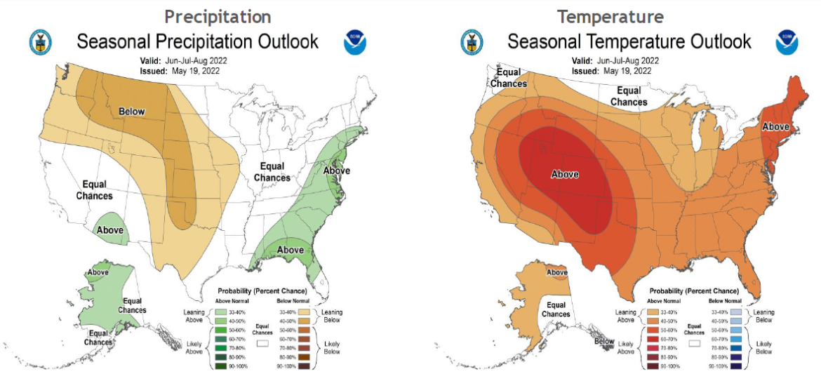
US Seasonal Outlook June – August 2022 [NOAA Climate Prediction Center
There is one other notorious factor in the Atlantic hurricane season: The Loop Current. University of Miami oceanography professor Nick Shay referred to it as “the 800-pound gorilla in the Gulf.”
The Loop Current is a field of warm salty water in the Gulf of Mexico. It powers the Florida current and ultimately joins the Gulf Stream, and it also adds fuel to hurricanes and it has moved farther north.
Storms crossing the Loop Current or one of its eddies can draw more energy and intensify rapidly. It was responsible for the intensification of famous storms like Rita, Wilma, and Katrina in 2005.
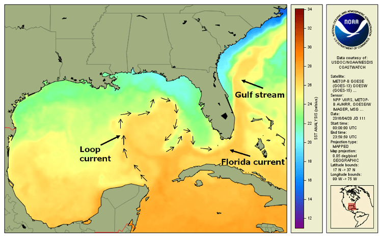
The Gulf of Mexico loop current on April 20, 2016 as shown by the CoastWatch GOES-POES Global Sea Surface Temperature product. [NOAA]
Hurricane forecasters say that while this season may be similar to last year, the adage goes that you only need one bad storm for life to change drastically.
The Hurricane Center says that preparation and information are key to surviving hurricanes. Secretary of Commerce Gina M. Raimondo said that “throughout the hurricane season, NOAA experts will work around-the-clock to provide early and accurate forecasts and warnings that communities in the path of storms can depend on to stay informed.”
The same is true, says NOAA, for the weather effects of La Niña. Whether for it or hurricanes, NOAA stresses now is the time to prepare.
Resources
- National Hurrican Preparedness – NOAA
- What Should You Do Before a Hurricane? – The American Red Cross
- Hurricanes – Ready.gov
- Hurricane Safety Checklists – National Hurricane Survival Initiative
- La Niña prediction – Climate Prediction Center
- Local Emergency Management is your critical resource during natural events. Please pay close attention to your local emergency management agency.
The Wild Hunt is not responsible for links to external content.
To join a conversation on this post:
Visit our The Wild Hunt subreddit! Point your favorite browser to https://www.reddit.com/r/The_Wild_Hunt_News/, then click “JOIN”. Make sure to click the bell, too, to be notified of new articles posted to our subreddit.