VANDENBERG, Ca. – On Saturday, the Sentinel-6 satellite successfully launched into orbit from Vandenberg, California, aboard a SpaceX Falcon-9 rocket. The satellite, codenamed “Michael Freilich” after the late NASA director of Earth sciences, is part of a collaboration between the European Space Agency (ESA) and NASA. It will provide crucial data for monitoring climate change by tracking the rise of the Earth’s oceans.
“With global mean sea level rising because of climate change,” the mission’s comments note, “Copernicus Sentinel-6 is the next radar altimetry reference mission to extend the legacy of sea-surface height measurements until at least 2030.”
NASA noted that Sentinel 6 will be able to measure how Earth’s atmosphere and ocean are inextricably linked to one another. The mission is equipped with a speciated altimeter and a microwave radiometer to measure sea level heights and changes.
“Sentinel-6 Michael Freilich is a milestone for sea level measurements,” said Project Scientist Josh Willis of NASA’s Jet Propulsion Laboratory in Southern California, which manages NASA’s contributions to the mission. “It’s the first time we’ve been able to develop multiple satellites that span a complete decade, recognizing that climate change and rising seas are here to stay.”

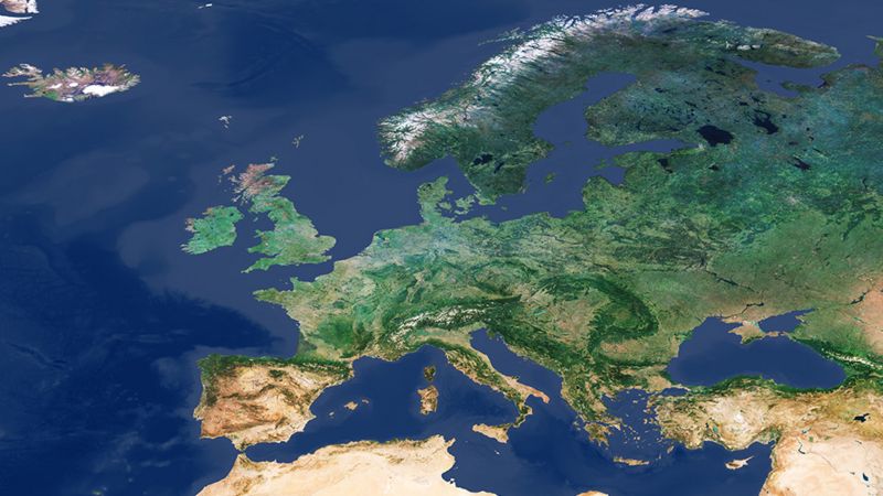
Copernicus image showing parts of Eurasia and Africa [ESA/SENTINEL 3]
The Sentinel series of missions is part of ESA’s Copernicus Program, which continuously and systematically acquires high-resolution imagery and data from landmasses and their coastal waters. The Sentinel missions map a range of activities, including arctic sea ice, glacier monitoring, agricultural activity, and water quality, while also supporting a range of services including emergency management and risk analysis.
The Copernicus Program is a coordinated Earth observation mission aimed at achieving high-quality, autonomous, and continuous observations of the planet. The ESA notes that Copernicus “will provide accurate, timely, and easily accessible information to improve the management of the environment, understand and mitigate the effects of climate change, and ensure civil security.” Its name pays homage to Nicolaus Copernicus, whose theory of the heliocentric universe made a pioneering contribution to modern science.
“Copernicus provides a unified system,” states the mission’s overview, “through which vast amounts of data are fed into a range of thematic information services designed to benefit the environment, the way we live, humanitarian needs and support effective policy-making for a more sustainable future.” This aim is fulfilled by the Sentinel family of satellites, as well as ground-based systems that coordinate data.

Sentinel family of satellites [European Space Agency]
The ESA launched Sentinel 2a and Sentinel 2B in 2015 and 2017, respectively. The pair of low-Earth-orbit Sentinels are equipped with high-resolution multispectral cameras and perform Earth observations to support forest management, monitor forest destruction, and provide up-to-date information for natural disaster management, as well as to locate sites during humanitarian crises such as refuge migration. The satellites can also help predict water and fertilizer usage and needs to prevent food shortages. Sentinel 2B performs very similar tasks.
Sentinel 3A and Sentinel 3B, launched in 2016 and 2018, respectively, monitor the oceans and provide important data to monitor climate change, including sea topography, sea surface temperatures, and sea-to-land contrasts. These systems help monitor sea-water quality and pollution, as well as support fire detection and weather forecasting.
Sentinels 4 and 5 have not yet launched, but their missions have already been identified. Sentinel 4 will conduct atmospheric monitoring and is scheduled to launch in 2023. Sentinel 5 will monitor polar systems, and is scheduled to launch next year.
In July 2020, the Copernicus Program announced six additional satellite missions as part of their 2.0 expansion. These satellites will expand ocean and land monitoring, adding polar ice and snow observations, a detailed radar system, and anthropogenic CO2 emissions monitoring. Codenamed CO2M, Airbus Germany was contracted to develop the system that measures carbon dioxide concentrations in the atmosphere. A similar system called CRISTAL will be developed by Airbus Germany to measure the shape and thickness of polar ice.
As part of these missions, the ESA announced contracts for the development of systems to support the new Sentinels.
Thales Alenia Space (TAS), a French-Italian aerospace manufacturer, was awarded €455m at its French site to procure two satellites and develop the Copernicus Hyperspectral Imaging Mission for the Environment (CHIME), a specialized and high-resolution imager to gather comprehensive information on plant health. This will be particularly helpful in crop management.
TAS-Italy was also awarded a contract to procure two spacecraft and develop the Copernicus Imaging Microwave Radiometer, a microwave device that detects electromagnetic radiation to measure not only sea surface temperature but also salinity and sea-ice concentration.
TAS-Italy will also be developing a mission codenamed ROSE-L that can monitor land subsidence and soil moisture to help with precision farming and improve food security. The system will also be able to measure vegetation and different types of snow and ice.
Airbus Spain was awarded €380m to procure two satellites and develop a specialized thermal sensor for land surface temperature monitoring to predict drought and support agricultural activities.
When fully implemented, the Copernicus program will offer comprehensive monitoring of the Earth in support of the planet’s health that is intimately and inseparably tied to humanity’s wellbeing. Copernicus Program data will be available to the public.
The Wild Hunt is not responsible for links to external content.
To join a conversation on this post:
Visit our The Wild Hunt subreddit! Point your favorite browser to https://www.reddit.com/r/The_Wild_Hunt_News/, then click “JOIN”. Make sure to click the bell, too, to be notified of new articles posted to our subreddit.